Day 1: Saturday June 23rd 2007, 565 Km, 18 hrs
Well my much awaited trip ..the one I have been waiting for quite some time was going to materialize in a few hours and the very thought was driving me crazy. Me and two of my friends..Jaggu and Kishore left Delhi in the wee hrs of Saturday, June 23rd 2007. At 1:40 am we were already underway after doing required packing and running thru the checklist. Delhi is too dusty at this hr with trucks plying on almost all the roads, so we tried to get as far away from heat and dust of delhi, and as quickly, as possible.
By 4:15 am we had already crossed Karnal. We had some coffee at a dhaba and spent some time there. soon we left for Ambala.We crossed Kurukshetra at 5:31 am and reached Chandigarh at 7:15 am. At around 8:15 am we had breakfast somewhere in between Chandigarh and Ropad. At 10:20 am we were at Kiratpur filling up the tanks of our thristy bikes.... Kiratpur is at the foothills and the turns start from here.
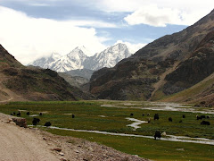
Till now we were just covering the distance..the real trip started now...I enjoy driving in the fresh air of mountains, and the chilly winds took away all the tiredness and re-energized the body. At 12:00 pm we had lunch at Bilaspur. According to the odometer of my bike, we had already covered 326 kms. Now the aim was to reach Manali as quickly as possible..but I started to feel sleepy near Mandi..so had to stop for a tea break. We finally reached Manali at 7:20 pm and by 8:00 pm reached Hotel Brighu, vashistha, Manali. The view from the hotel is perfect with one side looking over to the wide bed side of river Vyas with apple orchards on the sides.

Total distance covered 565 kms.
 s and of course filled ours as well..southindian style. The service was very bad and it took them ages to get our food ready. We finally left for Rohtang Pass at 11:15 AM. Rohtang means a pile of dead bodies'( roh-dead body, tang-pile). Many died while crossing this tough pass in earlier days..hence the name. However it is much easier now, provided you escape the swarm of tourists flocking this picturesque pass. The situation with the jams here is so bad that in the peak season, sometimes you don't even get to go all the way up to the Rohtang Pass.

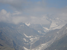
We were lucky as we reached the hill top without any trouble. The weather gods, however, were still not smiling at us as it was cloudy and a bit foggy. Although I love biking in such weather, but at the same time I was missing the beautiful landscape that this place presents. The ascent to the Rohtang Pass is quite steep and your bike is constantly on the 1st and 2nd gear. We reached Rohtang at 2:15 PM after having a small tea break at Marhi, which is some 16 kms before Rohtang Pass. Rohtang is around 57 kms from Manali.
One thing that I must mention here is the peculiar nature of Rohtang pass. No matter how the weather is at the Manali side of it, you will always find clear weather on the other side. This is because the other side is a Rain Shadow region. That's why I strongly suggest anyone visiting Rohtang Pass to go 1 km further and see this phenomenon and the amazing beauty of Lahaul valley that lies there. With sharp and pointed prism like peaks, Lahaul valley welcomes you and presents a spectacular view.

We left Rohtang around 4:00 PM. At 4:30, we were at the diversion at Gramphoo. You go straight if you are going to Ladakh. Nonetheless we turned right and moved towards Chatdu, which was our next stop. Jaggu was out of our sight, as Kishore and I were stopping every now and then to click photographs, but we soon found Jaggu standing by the road side. A stream of ice cold water was flowing across the road, which was filled with big stones. Jaggu tried to cross it and got stuck and decided to wait for us. On reaching there, I decided to cross it first. As soon as my feet touched the icy water, a shiver ran through my spine and I could feel what lies ahead. Somehow we managed to cross the stream, but we were wet up to our knees and feeling really cold. We reached Chattdu by 6:00 pm, a small maggi break, and left for Batal which is 32Kms from there. We had planned to halt at Batal for the night and then conquer Kunjum La the next morning. One can spend night at Chattdu as well. There aren't any hotels as such, but the two restaurants here double up as a dormitory and these guys have nice and clean beds on offer.
Move a bit further and you will find yourself in barren land with only huge rocky mountains. No vegetation at all...just rocks. Chandra river flows by the side of the road and you are riding on the river bed, literally. There is no such thing as road here... the river bed is the road. Whatever is left of the road, cannot actually be called a road. We passed Chotta Dara at 7:00 PM. There is nothing here except a Gov. rest house, which seemed deserted, and a notice board saying this place is Chotta Dara.

It had started to get dark by this time. I just thought it would be a good idea to stop for a while and stay quiet and feel and absorb the beauty of this place. So we just switched off the engine of our bike. Suddenly in the quietness that prevailed after our bike went silent, all we could see is the ghost like mountains and the sound of wind which suddenly started to blow fiercely, as if in some hurry. As the environmen t sunk in, I felt a bit scared. Night had fallen by now and Jaggu was nowhere near. Kishore and I decided its time to hit Batal straightaway. We suddenly felt an urgency to reach Batal, esp as we hadn't seen anybody since we left Rohtang, except at Chattdu. Now we were riding with the headlights on, not speaking at all. I stopped abruptly, as it was a dead end. It seemed the entire mountain had fallen on the road. But then where was Jaggu? How could he possibly have crossed that or had we taken wrong road? We were just discussing these possibilities when we saw a headlight flashing at a distance. It was Jaggu who was signalling at us. He came closer, we could now see him down there by the river side, shouting something, but couldn't hear anything as strong wind was blowing. He was signalling towards some place behind us. The diversion was there..but we missed it because of darkness.
Jaggu had spent some 30 anxious moments concerning about us. When he crossed this hurdle he decided to wait for us. When we didn't turn up for 15-20 mins he got distressed. Lone biker's fears gripped him. When we met, it was excitement all over. Jaggu and I hugged each other and Kishore helped himself with a cigarette. We already got the adventure we were looking for from this trip on the second day itself.


As we moved further, we saw a milestone indicating that Batal is just 2 kms away. We thought 'ok! its over for the day', but it wasn't to be.......... We made a mistake and accidentally skipped Batal. Actually we crossed Batal at around 8:00 pm but moved ahead thinking it's still some kms away and reached Kunjum La(4551 m) instead. A second bout of excitement hit us as we reached Kunjum La at 10:30 PM. Jaggu and I started shouting slogans, Kishore stayed calm, may be concerned a bit as it was really-really cold. Then we started backwards journey looking for Batal and finally reached there at 11:00 PM. By this time headache had gripped me. Don't know if it was the cold or the altitude at Kunjum La that caused it, but I couldn't eat anything and went to sleep.

Just before Batal one gets fascinating view of Bara-Sigri glacier, the largest in Himachal Pradesh. We missed it as it was already dark when we passed it.
Day3: Monday, June 25th 2007, 117 Km, 9 hrs 30 min
The morning at Batal was bright with snow capped peaks all around. I was n't feeling comfortable with slight headache still bothering me. Still had breakfast and left for Chandra Tal at 9:45 AM. We were running short of Petrol and while still at Batal asked some passing by Britishers for petrol but they refused to help. Soon the climb to Kunjum La started. After around 2 kms, road bifurcates and one has to take left for Chandra Tal.
 We took this road for Chandra Tal, and it turned out to be the worst road, if it can be called one, that we had faced so far. It took us 1 hr to cover these 15 Kms from Batal to Chandra Tal, and we were driving non stop. But the beauty of the valley more than made up for the road. There are no mile stones and I started to feel that Chandra Tal must have dried up, but finally we reached Chandra Tal at 10:45 AM.
 Beautiful Lake with crystal clear water, with the sepia coloured mountains reflecting from its shinning mirror like water, presented a breathtaking sight. We spent around 1 and 1/2 hr there and then left for Kunjum La at 12:25 PM. Reached Kunjum La at 1:45 pPM. Again it took us another 95 mins to cover these 21 kms. The ascent to Kunjum la is steep, and the entire road is nothing more than a dirt track. The stones strewn all over it make life even more difficult for a biker, with hair-pin bends being the toughest to negotiate. All this while we were almost driving in first gear, and with Kishore as pillion, I was literally killing my bike. But it never disappointed me, and we reached Kunjum La without much difficulty. I was driving a Unicorn and jaggu RX 100.


Kunjum La(4551 m) is a high mountain pass in the himachal pradesh. On one side of it is Lahaul valley, on the other is the Spiti Valley. One can see the peaks of Chandra-Bhaga range on the eastern side, which stay snow covered round the year. There is a temple dedicated to goddes Durga at the top and each passing vehicle takes a round around it to seek the blessing of the Goddess. We did the same and continued to march forward, downhill to the beautiful spiti valley. We left Kunjum La at 2:15 Pm and reached Losar by 3:20 PM, some 19 kms from Kunjum La. Losar is considered as the gateway to the spiti valley. One can see gome greenery in the Spiti Valley.
 We had lunch here and registered ourselves with the check post. Left losar at around 4:45 PM.
Moving towards Kaza, we passed two places Kyoto and Kyurick . Kyoto is a beautiful place with a small monestry. And it seems everyone in Kyurick is waiting for bikers to pass through the place so that they get a chance to wave their hands at them. Nice friendly people I would say. Just after kyoto, suddenly sky turned grey and we could feel small water droplets on our faces. We stopped to take stock of the situation and could see that it was raining in the direction we were travelling, but we decided to keep moving. Just as we were about to move, we witnessed a beautiful Rainbow, and named the place Rainbow Point (this place is four kms from kyoto).
 At 5:57 PM we were at Hull, waiting for the rain to stop. Kaza is 25 kms from here and jaggu's bike was now running in reserve. We had to stop here because weather was threatening and moderate rain started. We took this opportunity and had tea and a chance to interact with local people.
  Soon we left Hull and reached Kaza at quarter past seven. Kaza is a full fledged town, with a local bus stop. Bus services from here are available to all the major places in Himachal.
Total distance covered by us in 3 days - 826 km. And yes, there is a petrol pump here as well, but it was already closed by the time we reached.
Day 4: Tuesday, June 26th 2007, 166 Km, 9 hrs 45 min
 The first thing we did in the morning is to fill the tanks of our bikes. Our plan for the day was to visit Kibber first. This is a small village, well connected with road and at 4328 m, holds the distinction of being the highest inhabited village in the world. It is some 20 kms from kaza and it
  took us around 1 hr to reach the village. At 12:45 PM, we were having lunch in Kibber. This place boasts of a post office as well as a dispensary. You could even see girls and boys playing Volley-Ball in the local high school. This village is indeed inhabited by happy and content people, mostly Tibetans.
 On our way back from Kibber, we halted for a while at Key Monastery. Perched atop a limestone rock, this monastery is perfectly located and looks like a triangle hanging from the mountains. We reached kaza at 3:16 PM. Had some snacks there and left for Nako at 3:40 PM, our night halt for the day.
Now we were driving on nice roads, but still risky for a two wheeler as they were covered with sand and small stones, rendering them highly skiddy. We reached Tabo at 5:25 PM, which is 48 Kms from Kaza. We had a small break here and had tea and omelets. There is a monastery here as well, but we couldn't visit it as we were getting late. The landscape here is vastly different from Lahaul Valley. The rude rocky mountains and narrow valley has given way to beautiful smooth slop mountains, as if made out of sand only. There is some greenery here as well, but that's mostly due to the combined effort of Govt. and local people under the "" scheme.
 We left Tabo at 6:20 PM and decided that we will now not stop for photographs and needless breaks as we wanted to reach Nako before dusk, as what happened last night was still fresh and we didn't want to repeat the same mistake of driving under lights in a place where you really have to find the road. There are almost no driving directions and is really hard to find anyone after dusk.
Nako is situated at an altitude of 3,662 m above sea level. As the dawn was breaking through, steep ascent welcomed us before Nako. Now the bikes were running in 1st gear only. The terrain suddenly turned rocky and looked dangerous. We reached the ridge and drove along the ridge for some time. Road now was good only in patches. At one point our bikes refused to budge as it was steep and muddy road. A truck was stuck there, the driver and helper struggling to move it even inches. The helper was pushing bricks under the wheel to stop it from sliding down while the driver was trying to pull it in small bursts. Well, it took us 15 mins but were able to push through. I had to really push the bikes from behind and was gasping for breath. And as if it wasn’t enough, just a few meters ahead heavy water was flowing through the road. It was completely dark by now and we crossed it with some difficulty, getting wet again in the process.
 The nullah was the highest point and now we were driving down hill. We thought Nako cannot be more than 2kms from there, just a matter of time before we would reach there. But it wasn’t to be, as a truck had overturned in the middle of road some 20 minutes ago.Time: 8:26 pm. It was positioned in such a way that it left no space even for a bike to pass. It was loaded with Matar(Sweet pea) and was going to Theog mandi. We had to throw some Matar bags to make some space and somehow managed to sneak our bikes through. We crossed this hurdle at 8:36 pm.
After exercising extreme caution to not miss the destination this time, we were again done in by the darkness. This time however the boards were in place and I saw them too, but thought it must be some other place as a motorist had just told us that Nako is 10 kms away.
Minutes later we were cursing ourselves for not having faith in our distance calculations and for believing whatever others were telling us. We had again gone 8 kms farther from our destination. Finally reached Nako at 9:30 pm. Trouble at night had become a regular feature by then.
Day 5: Wednesday, June 27th 2007, 196 Km, 10 hrs
We took a small round around the village in the morning. Small but beautiful village, providing some greenery to the otherwise pale and rocky terrain. There is a small lake at Nako and the place is just 5 kms from the Indo-China border. In fact we can even see the mountains on the Chinese side of border from Nako.
 We lef Nako at .11:45 am and soon we were driving downhill on a nice track. At around 35 deg slope, it was too slopy for comfort and you could see a board warning motorist to check brakes. Soon we reached the base of mountains and roads again turned into dirt track. Now we were driving besides the gushing Satluj river. We reached Spilo at 2:18 pm . Had lunch there and spend some 30 mins there. Moving on, one could see some greenery.
Soon we entered the Kinnaur Valley and it was refreshing to see green beauty again. Greenery, small villages , huge mountains, Satluj river and decent roads make it a place to visit. We had planned to reach Narkanda and stay there for the night but couldn't go beyond Rampur, as Jaggu took a wrong road(again) and we wasted more than an hour in the process. There is a mighty fall in Kinnaur just after the Apka bridge. One can see a lots of tunnels and other work going on in the area, for some hydro power project. We reached Rampur at 9:30 pm, but it took us an hour to find a suitable hotel. At 1350 m, Rampur is a rather hot place.
Day 6: Thursday, June 28 2007, 195 Km, 9 hrs
It was going to be a rather long day as we had planned to reach delhi the same day. But we started late as all of us struggled to get up early. We left Rampur at 11:00 pm. The stretch from Ramput to Narkanda is just out of this world. Roads are smooth and wide, and one sees lush greenery after months of rains the region's been receiving, unlike the lahaul-Spiti valley which receives very little rainfall. Light showers greeted us at Narkanda. We reached there at 1:30 pm. Narkanda is famous for its ski slopes and receives heavy snowfall in the winter season, and it's just 64 kms from Shimla.
We left Narkanda at 2:15 pm, but instead of going straight to Shimla we decided to pass via Chail. We reached Chail at 5:15 pm. The road wasn't good and we were travelling slowly. After having some food, we left Chail and managed to reach Solan by 8:00 pm. We decided to halt at Solan for the night.
Day 7: Friday, June 29 2007, 324 Km, 11 hrs
Well, the only aim was to reach Delhi without wasting any time and it was again that phase of the trip where we merely cover distance. We hadn't had any trouble in reaching Delhi and by 7:00 pm we were sitting in Jaggu's apartment transferring and sharing photographs between us.
Total Distance Covered: 1707 Kms.
Things to remember:
When going on such a trip, one must ensure that a few things are in place..We checked the following items:
1. Spare tubes and the tools required to fix them. Some puncture mending mterials.
2. Spare spark plug.
3. Spare clutch wires.
4. Foot pump.
Well my much awaited trip ..the one I have been waiting for quite some time was going to materialize in a few hours and the very thought was driving me crazy. Me and two of my friends..Jaggu and Kishore left Delhi in the wee hrs of Saturday, June 23rd 2007. At 1:40 am we were already underway after doing required packing and running thru the checklist. Delhi is too dusty at this hr with trucks plying on almost all the roads, so we tried to get as far away from heat and dust of delhi, and as quickly, as possible.
By 4:15 am we had already crossed Karnal. We had some coffee at a dhaba and spent some time there. soon we left for Ambala.We crossed Kurukshetra at 5:31 am and reached Chandigarh at 7:15 am. At around 8:15 am we had breakfast somewhere in between Chandigarh and Ropad. At 10:20 am we were at Kiratpur filling up the tanks of our thristy bikes.... Kiratpur is at the foothills and the turns start from here.
Till now we were just covering the distance..the real trip started now...I enjoy driving in the fresh air of mountains, and the chilly winds took away all the tiredness and re-energized the body. At 12:00 pm we had lunch at Bilaspur. According to the odometer of my bike, we had already covered 326 kms. Now the aim was to reach Manali as quickly as possible..but I started to feel sleepy near Mandi..so had to stop for a tea break. We finally reached Manali at 7:20 pm and by 8:00 pm reached Hotel Brighu, vashistha, Manali. The view from the hotel is perfect with one side looking over to the wide bed side of river Vyas with apple orchards on the sides.

Total distance covered 565 kms.
Day 2: Sunday, June 24th 2007, 144 Km, 13 hrs 30 min
Well the weather wasn't good and we left the hotel at 9:30 am speculating about the weather. We filled the bellies of our bike s and of course filled ours as well..southindian style. The service was very bad and it took them ages to get our food ready. We finally left for Rohtang Pass at 11:15 AM. Rohtang means a pile of dead bodies'( roh-dead body, tang-pile). Many died while crossing this tough pass in earlier days..hence the name. However it is much easier now, provided you escape the swarm of tourists flocking this picturesque pass. The situation with the jams here is so bad that in the peak season, sometimes you don't even get to go all the way up to the Rohtang Pass.
We were lucky as we reached the hill top without any trouble. The weather gods, however, were still not smiling at us as it was cloudy and a bit foggy. Although I love biking in such weather, but at the same time I was missing the beautiful landscape that this place presents. The ascent to the Rohtang Pass is quite steep and your bike is constantly on the 1st and 2nd gear. We reached Rohtang at 2:15 PM after having a small tea break at Marhi, which is some 16 kms before Rohtang Pass. Rohtang is around 57 kms from Manali.
One thing that I must mention here is the peculiar nature of Rohtang pass. No matter how the weather is at the Manali side of it, you will always find clear weather on the other side. This is because the other side is a Rain Shadow region. That's why I strongly suggest anyone visiting Rohtang Pass to go 1 km further and see this phenomenon and the amazing beauty of Lahaul valley that lies there. With sharp and pointed prism like peaks, Lahaul valley welcomes you and presents a spectacular view.

We left Rohtang around 4:00 PM. At 4:30, we were at the diversion at Gramphoo. You go straight if you are going to Ladakh. Nonetheless we turned right and moved towards Chatdu, which was our next stop. Jaggu was out of our sight, as Kishore and I were stopping every now and then to click photographs, but we soon found Jaggu standing by the road side. A stream of ice cold water was flowing across the road, which was filled with big stones. Jaggu tried to cross it and got stuck and decided to wait for us. On reaching there, I decided to cross it first. As soon as my feet touched the icy water, a shiver ran
 through my spine and I could feel what lies ahead. Somehow we managed to cross the stream, but we were wet up to our knees and feeling really cold. We reached Chattdu by 6:00 pm, a small maggi break, and left for Batal which is 32Kms from there. We had planned to halt at Batal for the night and then conquer Kunjum La the next morning. One can spend night at Chattdu as well. There aren't any hotels as such, but the two restaurants here double up as a dormitory and these guys have nice and clean beds on offer.
Move a bit further and you will find yourself in barren land with only huge rocky mountains. No vegetation at all...just rocks. Chandra river flows by the side of the road and you are riding on the river bed, literally. There is no such thing as road here... the river bed is the road. Whatever is left of the road, cannot actually be called a road. We passed Chotta Dara at 7:00 PM. There is nothing here except a Gov. rest house, which seemed deserted, and a notice board saying this place is Chotta Dara.

It had started to get dark by this time. I just thought it would be a good idea to stop for a while and stay quiet and feel and absorb the beauty of this place. So we just switched off the engine of our bike. Suddenly in the quietness that prevailed after our bike went silent, all we could see is the ghost like mountains and the sound of wind which suddenly started to blow fiercely, as if in some hurry. As the environmen
 t sunk in, I felt a bit scared. Night had fallen by now and Jaggu was nowhere near. Kishore and I decided its time to hit Batal straightaway. We suddenly felt an urgency to reach Batal, esp as we hadn't seen anybody since we left Rohtang, except at Chattdu. Now we were riding with the headlights on, not speaking at all. I stopped abruptly, as it was a dead end. It seemed the entire mountain had fallen on the road. But then where was Jaggu? How could he possibly have crossed that or had we taken wrong road? We were just discussing these possibilities when we saw a headlight flashing at a distance. It was Jaggu who was signalling at us. He came closer, we could now see him down there by the river side, shouting something, but couldn't hear anything as strong wind was blowing. He was signalling towards some place behind us. The diversion was there..but we missed it because of darkness.
Jaggu had spent some 30 anxious moments concerning about us. When he crossed this hurdle he decided to wait for us. When we didn't turn up for 15-20 mins he got distressed. Lone biker's fears gripped him. When we met, it was excitement all over. Jaggu and I hugged each other and Kishore helped himself with a cigarette. We already got the adventure we were looking for from this trip on the second day itself.


As we moved further, we saw a milestone indicating that Batal is just 2 kms away. We thought 'ok! its over for the day', but it wasn't to be.......... We made a mistake and accidentally skipped Batal. Actually we crossed Batal at around 8:00 pm but moved ahead thinking it's still some kms away and reached Kunjum La(4551 m) instead. A second bout of excitement hit us as we reached Kunjum La at 10:30 PM. Jaggu and I started shouting slogans, Kishore stayed calm, may be concerned a bit as it was really-really cold. Then we started backwards journey looking for Batal and finally reached there at 11:00 PM. By this time headache had gripped me. Don't know if it was the cold or the altitude at Kunjum La that caused it, but I couldn't eat anything and went to sleep.

Just before Batal one gets fascinating view of Bara-Sigri glacier, the largest in Himachal Pradesh. We missed it as it was already dark when we passed it.
Day3: Monday, June 25th 2007, 117 Km, 9 hrs 30 min
The morning at Batal was bright with snow capped peaks all around. I was
 n't feeling comfortable with slight headache still bothering me. Still had breakfast and left for Chandra Tal at 9:45 AM. We were running short of Petrol and while still at Batal asked some passing by Britishers for petrol but they refused to help. Soon the climb to Kunjum La started. After around 2 kms, road bifurcates and one has to take left for Chandra Tal.
 We took this road for Chandra Tal, and it turned out to be the worst road, if it can be called one, that we had faced so far. It took us 1 hr to cover these 15 Kms from Batal to Chandra Tal, and we were driving non stop. But the beauty of the valley more than made up for the road. There are no mile stones and I started to feel that Chandra Tal must have dried up, but finally we reached Chandra Tal at 10:45 AM.
 Beautiful Lake with crystal clear water, with the sepia coloured mountains reflecting from its shinning mirror like water, presented a breathtaking sight. We spent around 1 and 1/2 hr there and then left for Kunjum La at 12:25 PM. Reached Kunjum La at 1:45 pPM. Again it took us another 95 mins to cover these 21 kms. The ascent to Kunjum la is steep, and the entire road is nothing more than a dirt track. The stones strewn all over it make life even more difficult for a biker, with hair-pin bends being the toughest to negotiate. All this while we were almost driving in first gear, and with Kishore as pillion, I was literally killing my bike. But it never disappointed me, and we reached Kunjum La without much difficulty. I was driving a Unicorn and jaggu RX 100.

Kunjum La(4551 m) is a high mountain pass in the himachal pradesh. On one side of it is Lahaul valley, on the other is the Spiti Valley. One can see the peaks of Chandra-Bhaga range on the eastern side, which stay snow covered round the year. There is a temple dedicated to goddes Durga at the top and each passing vehicle takes a round around it to seek the blessing of the Goddess. We did the same and continued to march forward, downhill to the beautiful spiti valley. We left Kunjum La at 2:15 Pm and reached Losar by 3:20 PM, some 19 kms from Kunjum La. Losar is considered as the gateway to the spiti valley. One can see gome greenery in the Spiti Valley.
 We had lunch here and registered ourselves with the check post. Left losar at around 4:45 PM.
Moving towards Kaza, we passed two places Kyoto and Kyurick . Kyoto is a beautiful place with a small monestry. And it seems everyone in Kyurick is waiting for bikers to pass through the place so that they get a chance to wave their hands at them. Nice friendly people I would say. Just after kyoto, suddenly sky turned grey and we could feel small water droplets on
 our faces. We stopped to take stock of the situation and could see that it was raining in the direction we were travelling, but we decided to keep moving. Just as we were about to move, we witnessed a beautiful Rainbow, and named the place Rainbow Point (this place is four kms from kyoto).
 At 5:57 PM we were at Hull, waiting for the rain to stop. Kaza is 25 kms from here and jaggu's bike was now running in reserve. We had to stop here because weather was threatening and moderate rain started. We took this opportunity and had tea and a chance to interact with local people.
  Soon we left Hull and reached Kaza at quarter past seven. Kaza is a full fledged town, with a local bus stop. Bus services from here are available to all the major places in Himachal.
Total distance covered by us in 3 days - 826 km. And yes, there is a petrol pump here as well, but it was already closed by the time we reached.
Day 4: Tuesday, June 26th 2007, 166 Km, 9 hrs 45 min
 The first thing we did in the morning is to fill the tanks of our bikes. Our plan for the day was to visit Kibber first. This is a small village, well connected with road and at 4328 m, holds the distinction of being the highest inhabited village in the world. It is some 20 kms from kaza and it
  took us around 1 hr to reach the village. At 12:45 PM, we were having lunch in Kibber. This place boasts of a post office as well as a dispensary. You could even see girls and boys playing Volley-Ball in the local high school. This village is indeed inhabited by happy and content people, mostly Tibetans.
 On our way back from Kibber, we halted for a while at Key Monastery. Perched atop a limestone rock, this monastery is perfectly located and looks like a triangle hanging from the mountains. We reached kaza at 3:16 PM. Had some snacks there and left for Nako at 3:40 PM, our night halt for the day.
Now we were driving on nice roads, but still risky for a two wheeler as they were covered with sand and small stones, rendering them highly skiddy. We reached Tabo at 5:25 PM, which is 48 Kms from Kaza. We had a small break here and had tea and omelets. There is a monastery here as well, but we couldn't visit it as we were getting late. The landscape here is vastly different from Lahaul Valley. The rude rocky mountains and narrow valley has given way to beautiful smooth slop mountains, as if made out of sand only. There is some greenery here as well, but that's mostly due to the combined effort of Govt. and local people under the "" scheme.
 We left Tabo at 6:20 PM and decided that we will now not stop for photographs and needless breaks as we wanted to reach Nako before dusk, as what happened last night was still fresh and we didn't want to repeat the same mistake of driving under lights in a place where you really have to find the road. There are almost no driving directions and is really hard to find anyone after dusk.
Nako is situated at an altitude of 3,662 m above sea level. As the dawn was breaking through, steep ascent welcomed us before Nako. Now the
 bikes were running in 1st gear only. The terrain suddenly turned rocky and looked dangerous. We reached the ridge and drove along the ridge for some time. Road now was good only in patches. At one point our bikes refused to budge as it was steep and muddy road. A truck was stuck there, the driver and helper struggling to move it even inches. The helper was pushing bricks under the wheel to stop it from sliding down while the driver was trying to pull it in small bursts. Well, it took us 15 mins but were able to push through. I had to really push the bikes from behind and was gasping for breath. And as if it wasn’t enough, just a few meters ahead heavy water was flowing through the road. It was completely dark by now and we crossed it with some difficulty, getting wet again in the process.
 The nullah was the highest point and now we were driving down hill. We thought Nako cannot be more than 2kms from there, just a matter of time before we would reach there. But it wasn’t to be, as a truck had overturned in the middle of road some 20 minutes ago.Time: 8:26 pm. It was positioned in such a way that it left no space even for a bike to pass. It was loaded with Matar(Sweet pea) and was going to Theog mandi. We had to throw some Matar bags to make some space and somehow managed to sneak our bikes through. We crossed this hurdle at 8:36 pm.
After exercising extreme caution to not miss the destination this time, we were again done in by the darkness. This time however the boards were in place and I saw them too, but thought it must be some other place as a motorist had just told us that Nako is 10 kms away.
Minutes later we were cursing ourselves for not having faith in our distance calculations and for believing whatever others were telling us. We had again gone 8 kms farther from our destination. Finally reached Nako at 9:30 pm. Trouble at night had become a regular feature by then.
Day 5: Wednesday, June 27th 2007, 196 Km, 10 hrs
We took a small round around the village in the morning. Small but beautiful village, providing some greenery to the otherwise pale and rocky terrain. There is a small lake at Nako and the place is just 5 kms from the Indo-China border. In fact we can even see the mountains on the Chinese side of border from Nako.
 We lef Nako at .11:45 am and soon we were driving downhill on a nice track. At around 35 deg slope, it was too slopy for comfort and you could see a board warning motorist to check brakes. Soon we reached the base of mountains and roads again turned into dirt track. Now we were driving besides the gushing Satluj river. We reached Spilo at 2:18 pm . Had lunch there and spend some 30 mins there. Moving on, one could see some greenery.
Soon we entered the Kinnaur Valley and it was refreshing to see green beauty again. Greenery, small villages , huge mountains, Satluj river and decent roads make it a place to visit. We had planned to reach Narkanda and stay there for the night but couldn't go beyond Rampur, as Jaggu took a wrong road(again) and we wasted more than an hour in the process. There is a mighty fall in Kinnaur just after the Apka bridge. One can see a lots of tunnels and other work going on in the area, for some hydro power project. We reached Rampur at 9:30 pm, but it took us an hour to find a suitable hotel. At 1350 m, Rampur is a rather hot place.
Day 6: Thursday, June 28 2007, 195 Km, 9 hrs
It was going to be a rather long day as we had planned to reach delhi the same day. But we
 started late as all of us struggled to get up early. We left Rampur at 11:00 pm. The stretch from Ramput to Narkanda is just out of this world. Roads are smooth and wide, and one sees lush greenery after months of rains the region's been receiving, unlike the lahaul-Spiti valley which receives very little rainfall. Light showers greeted us at Narkanda. We reached there at 1:30 pm. Narkanda is famous for its ski slopes and receives heavy snowfall in the winter season, and it's just 64 kms from Shimla.
We left Narkanda at 2:15 pm, but instead of going straight to Shimla we decided to pass via Chail. We reached Chail at 5:15 pm. The road wasn't good and we were travelling slowly. After having some food, we left Chail and managed to reach Solan by 8:00 pm. We decided to halt at Solan for the night.
Day 7: Friday, June 29 2007, 324 Km, 11 hrs
Well, the only aim was to reach Delhi without wasting any time and it was again that phase of the trip where we merely cover distance. We hadn't had any trouble in reaching Delhi and by 7:00 pm we were sitting in Jaggu's apartment transferring and sharing photographs between us.
Total Distance Covered: 1707 Kms.
Things to remember:
When going on such a trip, one must ensure that a few things are in place..We checked the following items:
1. Spare tubes and the tools required to fix them. Some puncture mending mterials.
2. Spare spark plug.
3. Spare clutch wires.
4. Foot pump.